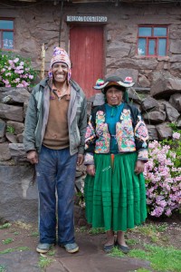
After Christmas had passed, we were more than ready to escape from Puno. Our main reason for coming to this region was to visit some of the local traditional communities in the area around the lake. Our first stop was to the Capachica Penninsula, where there are a handfull of tiny communities hugging the rocky mountains wich rise up out of the lake. Besides being nestled in such a gorgeous and untouched landscape, these communities are very infrequently touristed and the only accomodation available on the penninsula is homestay- which of course, is much of the fun!
Tag Archive > South America
Los Uros
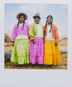
One of Peru’s top tourist attractions (after Machu Picchu) is the floating reed islands of Uros. We were less than excited about traveling to Uros, but of course we felt that we couldn’t come to Lake Titikaka without visiting this famous sight… The Islands have become very commercial, now relying entirely on tourism for thier existence and livelyhood. Still, thanks to the trusty Polaroid, this short visit was due to be one of the most memorable interactions with local people so far! One of the woman caught sight of my camera and asked about it- Of course, being a good photographer (and a mediocre Spanish speaker), I opted for a demonstation. It caused such a stir that soon all the islanders had gathered around each one yelling ‘Amigo, a mi, por favor!’ One after the other, I shot off the last of the pack of film, which regrettably I didn’t even get copies of before our boat was ready to leave… But the islanders were all so pleased with the unexpected souvenirs brought by the gringos, I’m happy to settle for memories!
One week in Hell
From the highland of Cusco, we headed east for the sweltering jungle port town of Puerto Maldonado. Lena was less than excited, with the prospect of heat and mosquitoes awaiting her. We spent almost two weeks, sweating in hammocks, swatting bugs of all shapes and sizes, riding in rickety canoes called Peke-Pekes headed for strange jungle settlements miles from any roads… I will even admit: It wasn’t the most comfortable two weeks of my life, but it did provide an interesting glimpse at jungle life- The real thing; where everyone’s uncle is a Shaman, small-scale gold mining is the main source of income, and platanos (bananas) are the main source of nutrition.
Sacred Valley
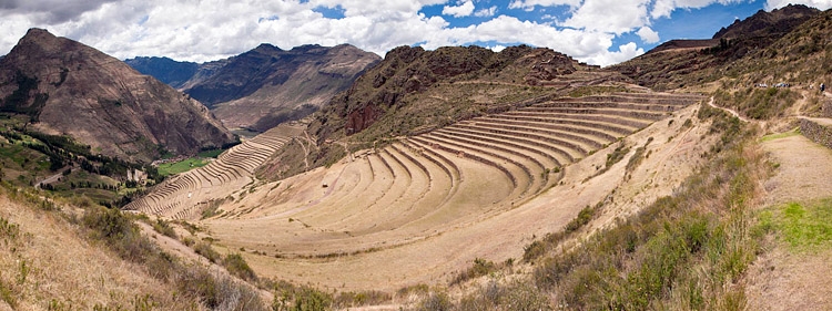
The area east of Cusco is called the Sacred Valley, because there are many ancient Inca ruins. We had just come back from Aguas Calientes and Machu Picchu, on our way back to Cusco, and we almost passed the Sacred Valley but it seemed it would have been stupid, not to look. Although I was a bit tired of all the Inca ruins, which we had already visited, including Machu Picchu, which is of course difficult to beat, However, from the beginning of the travels I had wanted to see the Sacred Valley. So, we ignored our fatigue and the desire to recover at Casa de Mama a little longer and explored this famous area.
Machu Picchu
The final destination of our Salkantay Trek, was of course the Inca ruins of Machu Picchu. I think Machu Picchu itself needs really no introduction… For us, it was the culmination of five rough days in the mountains, and for me: many years of dreams and wondering what such a place could actually be like. I have marveled at the possibility of this place since I was quite young, and came a across some photo in a book somewhere long forgotten. The image stayed in my mind for many years and every time since I came upon a photo of Machu Picchu my childhood wonderment and curiosity never ceased.
Salkantay
Lena and I decided to attempt the Salkantay Trail, a 56 km trail beginning in the small town of Mollepata, passing through a 4,800 meter pass next to Apu Salkantay, and finally ending in Aguas Calientes, at the base of Machu Picchu. We made the trek in five days, with no guide, and have put together this report to document our journey. There is a lot of information (and photos!) here, and I have tried to include as much information as possible for someone who wishes to attempt this trek on their own, as well as portray our personal journey on this trail. This post is divided into sections, beginning with an introduction to the trail, followed by a day-by-day summary of our adventures.
The famous Salkantay Trek, named among the 25 best Treks in the World, by National Geographic Adventure Travel Magazine, is a trek open to everybody, with no limitation on spaces or permits (at least for now). Connecting the city of Mollepata with Machu Picchu, the Salkantay Trek is an ancient and remote footpath located in the same region as the Inca Trail where massive snowcapped mountains collide with lush tropical rain forests.
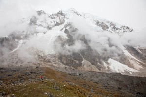
Located less than fifty miles northwest of the city of Cusco in south central Peru by the Cordillera Vilcabamba and rising to 6271 meters above sea level (20574 ft) Mt. Salkantay is an outstanding glacier-capped summit worshipped for thousands of years by local indians. The name Salkantay is a quechua word meaning “Savage Mountain” (From www.salkantay.org)
Jump to:
Salkantay Introduction
Day 1 – Cusco to Mollepata
Day 2 – Mollepata to Soraypampa
Day 3 – Soraypampa, Abra Salkantay, Huaracmachay, Chaullay
Day 4 – Chaullay, La Playa, Lucmabamba
Day 5 – Lucmabamba, Llactapata, Hydro Electrica, Aguas Calientes
Salkantay – Introduction
Salcantay (Nevado Salcantay) or Salkantay (Nevado Salkantay), Sallqantay in Quechua is the highest peak of the Cordillera Vilcabamba, part of the Peruvian Andes. It is located in the Cusco Region, about 60 km (40 mi) west-northwest of the city of Cusco. It is the 38th highest peak in the Andes, and the twelfth highest in Peru. However, as a range highpoint in deeply incised terrain, it is the second most topographically prominent peak in the country, after Huascarán. (Wikipedia)
This is truly a spectacular trek, and I hope that by providing this information, it may encourage more people to attempt it this trek on their own. There is a lot of vague and misleading information on the web, and we found it very hard to find decent information beforehand when planning our trip. One of the best resources by far that I came across while planning was Vova & Olga’s very accurate and detailed Salkantay Trek Report. This was integral in making our Salkantay trip a success, and we owe them a lot of gratitude for the information!
Jump to:
Day 1 – Cusco to Mollepata
Day 2 – Mollepata to Soraypampa
Day 3 – Soraypampa, Abra Salkantay, Huaracmachay, Chaullay
Day 4 – Chaullay, La Playa, Lucmabamba
Day 5 – Lucmabamba, Llactapata, Hydro Electrica, Aguas Calientes
Salkantay – Part 5
This is the fifth and final part in a five-part series documenting our journey trekking the Salktantay Trek, from Mollepata to Aguas Calientes and eventually reaching Machu Picchu…
Day 5: Lucmabamba – Aguas Calientes
Start: 07:15 – Lucmabamba (2,250m)
POI: 10:30 – Pass (2,800m)
POI: 11:00 – Llactapata (2,500m)
POI: 14:45 – Hidro Electrica (2,050m)
End: 19:00 – Aguas Calientes (2,250m)
Summary: About a three hour, steep uphill trail along a beautiful Inca footpath to reach another pass at 2,900 meters, before descending slightly to the Inca ruins of Llactapata. From Llactapata, it was an even steeper descent to the river before reaching Hidro Electrica. From there it was a relatively easy (flat) and beautiful walk along the train tracks to reach Aguas Calientes, our final destination of the trek.
Salkantay – Part 4
This is the fourth part in a five-part series documenting our journey trekking the Salktantay Trek, from Mollepata to Aguas Calientes and eventually reaching Machu Picchu…
Day 4: Chaullay – Lucmabamba
Start: 08:30 – Chaullay (2,950m)
POI: 09:00 – Collapampa (2,850m)
POI: 13:00 – Lluscamayu (2,600m)
POI: 15:00 – La Playa (2,100m)
End: 16:30 – Lucmabamba (2,250m)
Summary: Crossed the river after Chaullay and a short half-hour uphill to Collapampa. From here, the trail turned into a drivable road, and we were offered a ride to La Playa. We chose to continue the trail, and crossed the river again to the left bank, and followed the trail. The trail here was very rocky and at times steep, with more or less equal ascending and descending sections, though throughout the day we lost about another 700 meters of altitude. The vegetation and landscape continues to become increasingly tropical, and the day is hot and humid.
Salkantay – Part 3
This is the third part in a five-part series documenting our journey trekking the Salktantay Trek, from Mollepata to Aguas Calientes and eventually reaching Machu Picchu…
Day 3: Soraypampa – Chaullay
Start: 08:30 – Soraypampa (3,850m)
POI: 09:30 – Salkantaypampa (4,100m)
POI: 11:00 – Albra Salkanta (4,750m)
POI: 14:00 – Huaracmachay (3,900m)
POI: 16:45 – Rayan-Nyoc (3,450m)
POI: 17:15 – Andenes (3,350m)
End: 18:30 – Chaullay (2,950m)
Summary: Cold morning. Starting with a moderate ascent to Salkantaypampa, before ascending steeply with many switchbacks to Albra Salkantay. From the pass, a sharp, rocky decent to Huaracmachay. Terrain and flora begin to change rapidly as the trail descends further. Much milder temperatures towards the end of the day, reaching lower altitudes.




 | Powered by